Sunset Park Brooklyn wedding photography context and logistics
How Sunset Park fits within Brooklyn’s slope and corridors
Sunset Park sits on the western slope of south-central Brooklyn, running downhill from about 7th Avenue to the waterfront, with 5th and 8th Avenues acting as the main commercial spines. For couples already thinking in terms of Brooklyn neighborhoods, it’s effectively the band between Greenwood Heights to the north, Borough Park to the east, and Bay Ridge further southwest along the same avenues.
Formally described sources such as Sunset Park, Brooklyn – Wikipedia usually place the namesake park and the hilltop overlook close to the center of the neighborhood footprint. From there, blocks step down toward the harbor, shifting from rowhouse streets into heavier industrial and warehouse massing as you approach the waterfront and Industry City.
North–south streets between roughly 36th and 59th Streets climb or descend noticeably as you move west, which matters for anyone in formal clothing walking between locations. The flatter eastern side near Borough Park has a denser grid and fewer wide views; the western side offers the park, more sky, and the harbor-facing slope but requires more awareness of inclines, stroller traffic, and occasional street repairs on the steeper blocks.
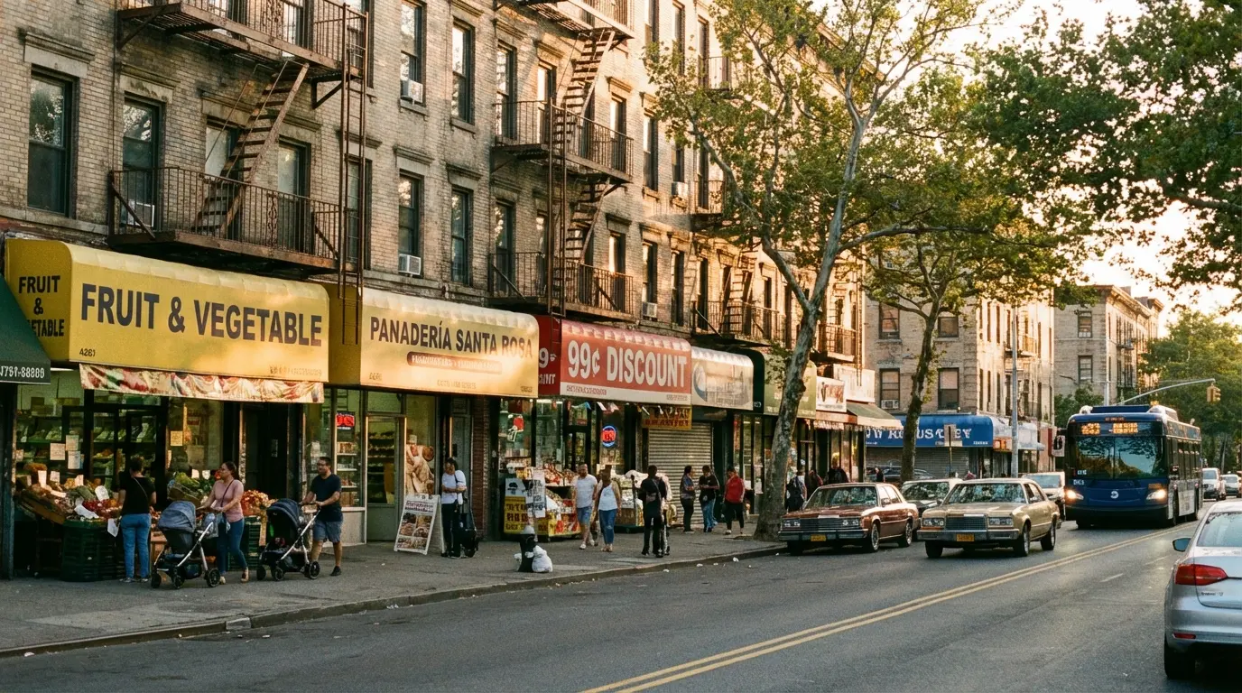
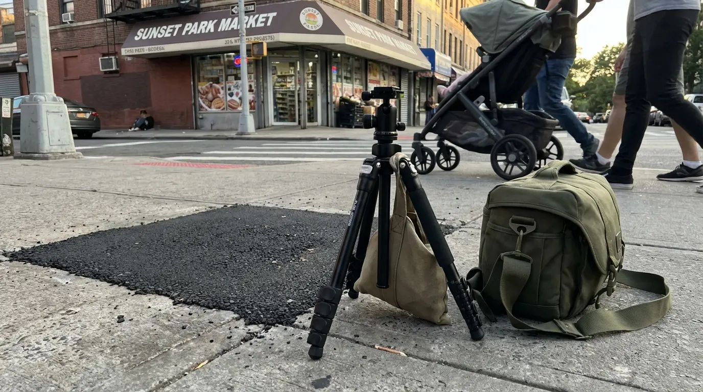
Shows the 5th Ave commercial rhythm, sidewalk width, corner-store clustering and occasional pavement repairs a buyer can verify when planning session locations and curb access.
This view of 5th Avenue makes clear how awnings, corner stores, and patched asphalt shape where a photographer can safely pause a couple or set down compact gear without blocking the sidewalk.
Where wedding photography actually concentrates in Sunset Park
Most wedding sessions in Sunset Park cluster in a few practical zones rather than spreading across the whole neighborhood. The hilltop inside the namesake park, the quiet residential blocks between roughly 5th–7th Avenues, and the perimeters of Industry City are the locations used repeatedly because they combine access, light, and realistic walking distances.
That pattern shapes how Wedding Photography here tends to use the hilltop skyline views, the warm brick rowhouse facades, and the industrial textures near the waterfront instead of chasing scattered “scenic spots.” The park offers the cleanest Manhattan-facing overlook; the residential blocks provide calmer, less cluttered backgrounds; and the industrial edge delivers a graphic, urban look without having to leave the neighborhood.
Sunset Park itself is an officially managed NYC park, with lawns, playgrounds, and the central overlook documented by Sunset Park – NYC Parks. Knowing where the playground, pergola, and main paths sit relative to the overlook helps anticipate passing families, stroller routes, and the small pockets where a couple can step aside briefly between groups.
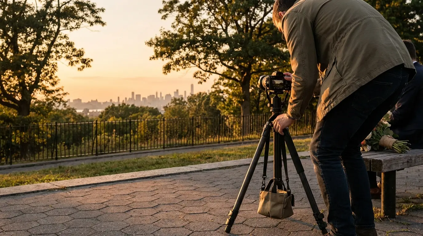
Verifies the hilltop vantage, view lines toward Manhattan and the extended golden-hour light characteristics a buyer can expect for on-site sessions.
You can see how the skyline, playground, and tree line sit in one frame, which is what most couples actually get when shooting on the hilltop rather than an empty-park ideal.
Choosing between park, corridor, and industrial settings
Couples usually choose between three Sunset Park looks: the green hilltop, the neighborhood street grid, or the commercial corridors and Industry City edge. Each has tradeoffs.
The park’s hill provides the widest sky and clearest horizon, but on weekends the playground funnels families and strollers along predictable loops past the overlook. That means brief windows between groups rather than long uninterrupted stretches of quiet. Shade from mature trees along the park perimeter also creates irregular bright and dark patches on nearby paths, so walking a few meters can change the light significantly on faces and dresses.
On 5th Avenue, continuous awnings, neon signs, and corner-store clusters define the background. Street repairs—especially fresh asphalt patches and temporary cones—show up along the curb, narrowing the usable strip where a couple can stand without stepping into traffic. Corner store “ecology” matters: people pause to chat, wait for coffee, or park strollers just outside entrances, so intersections tend to be the most crowded parts of the corridor.
8th Avenue, with its Chinatown storefronts, sees denser foot traffic and narrower sidewalks. Delivery carts, sandwich boards, and stroller routes compress the remaining space, which limits wider compositions and rules out large tripods or rolling cases during busy times.
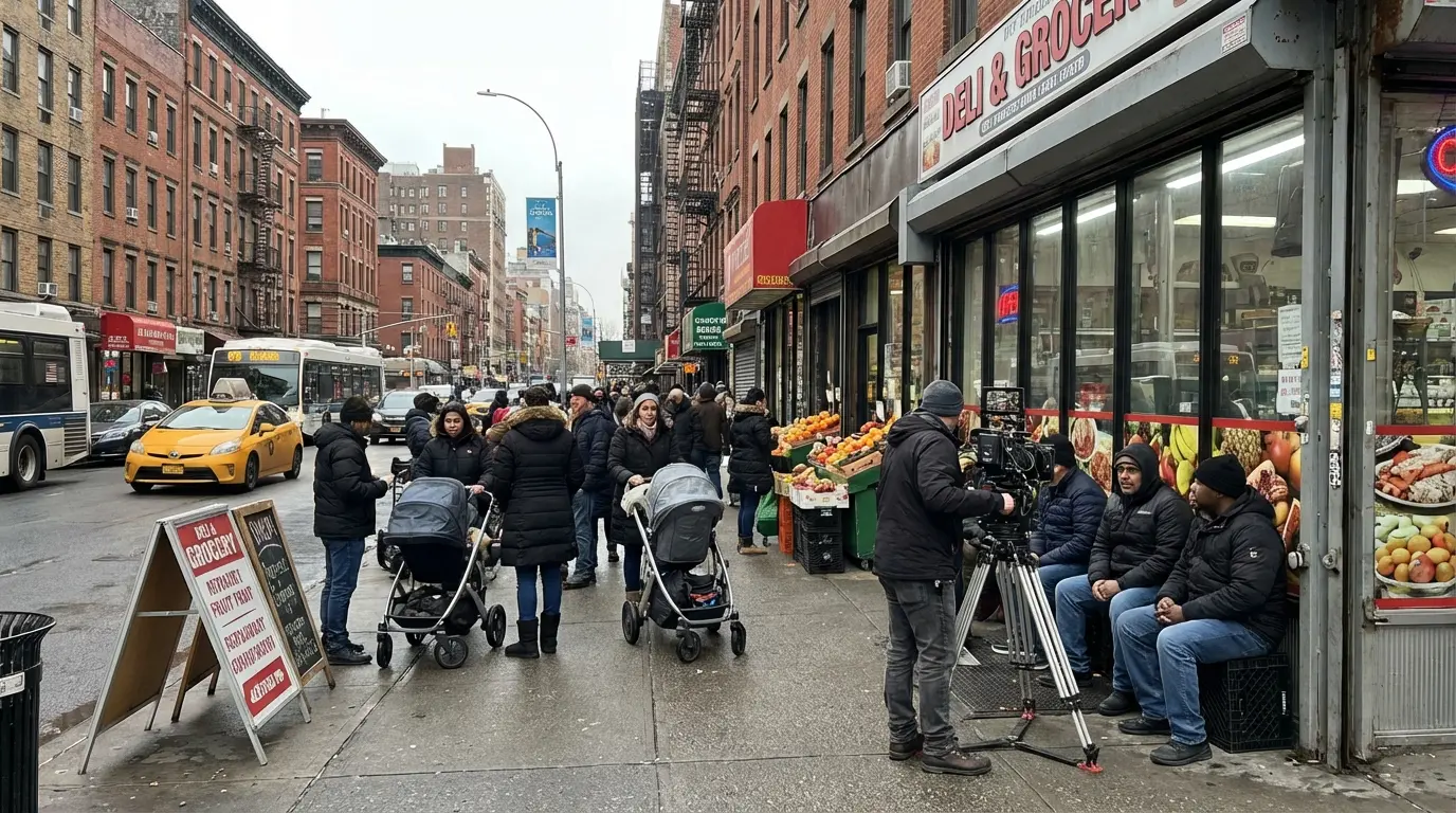
Helps buyers compare corridor constraints versus park locations by showing sidewalk width, stroller flows, and limited space for equipment or ride-share drop-offs.
This is a realistic view of how little clearance exists around a stroller or delivery stop, which is why most couples treat 8th Avenue as a transition route rather than their primary photo backdrop.
Moving between locations on a sloped wedding day
A typical Sunset Park session might start on the hilltop, shift to a nearby residential block, and, for some couples, finish near the industrial waterfront. The transitions between those locations are shaped by slope and side-street conditions more than by distance on a map.
Running east–west, streets like 36th, 45th, and 50th can feel steep in wedding attire, especially heading uphill from 5th Avenue toward 7th. On sloped sidewalks, minor street repairs—patched asphalt seams, utility cuts, or temporary plates—become tripping or stability concerns, both for heels and for any light stands or compact tripods. It’s common to plan routes that zigzag slightly to favor blocks with smoother paving.
Residential blocks between 6th and 7th Avenue are often used as a buffer zone: calmer than the corridors, with enough curb space to pause a car or small van for load-in. Shade-tree canopy is inconsistent here—some blocks have mature trees casting broken shade across stoops and parked cars, while others are open, producing stronger, more direct light.
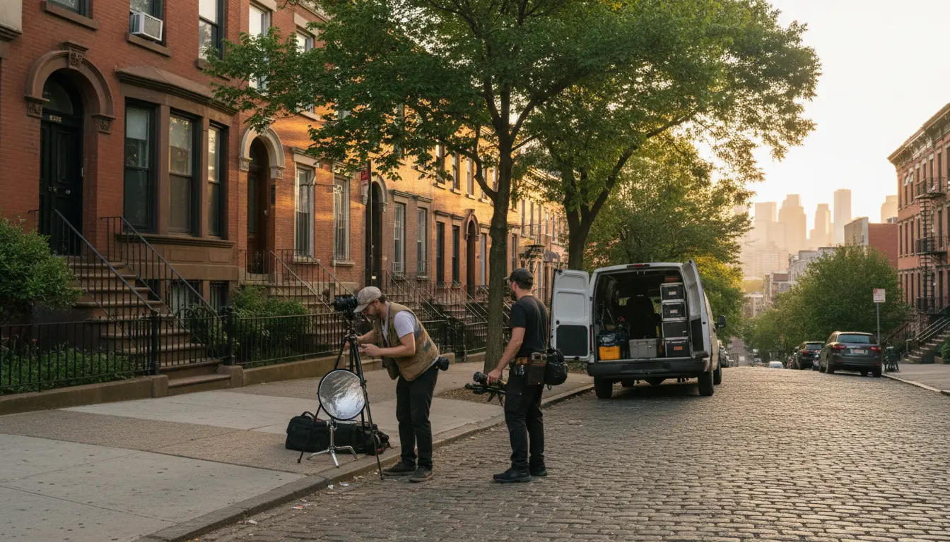
Demonstrates realistic on-street setup steps and constraints—slope handling, minimal gear footprint and load-in proximity—that buyers should expect for residential-block sessions.
The combination of a sloped sidewalk, parked vehicle for gear, and narrow working area is typical of these hill-adjacent blocks.
Professional Photography Options in Sunset Park
How the hill, trees, and buildings shape light
Because Sunset Park is a west-facing slope, light behaves differently here than in flatter parts of Brooklyn. In the morning, the hill itself blocks direct sun from the lower western blocks, leaving the park interior and the streets nearer to 5th Avenue in cooler, indirect light until mid-morning. This can be useful for elopements or small family photos on the overlook when couples want soft light but must start early.
By late afternoon, the hilltop opens to a broad western sky. Golden hour appears slightly “extended” on the overlook because there are fewer tall buildings in front of the sun; meanwhile, the lower industrial zone toward the waterfront drops into shade earlier, giving a 30–45 minute window of very soft, directional light against brick walls and loading bays.
Along 5th and 8th Avenues, metal awnings and glass storefronts create harsh reflections around midday. Combined with the patchy shade from intermittent street trees, this produces alternating bands of brightness and shadow across the sidewalk. For photos, it often makes more sense to step half a block onto a side street where tree canopy or building massing evens out the exposure rather than fighting the corridor’s narrow shafts of light.
Working within park rules, private space, and street conditions
From a feasibility standpoint, Sunset Park has both opportunity and constraint. The park’s hilltop can feel busy, particularly on warm-weather weekends when the playground and sports courts draw families from the surrounding grid. Crowd flow is fairly predictable—loops between the playground, benches, and overlook—but it means short, timed bursts for key portraits rather than a continuous private setting.
Industry City’s courtyards and internal passages are quasi-private. Security staff and posted rules vary by courtyard, and visible professional equipment (large softboxes, rolling cases, light stands) is more likely to draw attention than a small handheld setup. Expect that permissions may be needed for more formal or extended use, and that access can differ building to building even within the same complex.
On the streets, ongoing utility and resurfacing work shows up as uneven asphalt patches, open steel plates, or temporary cones, especially on sloped cross streets. These conditions matter for tripod stability and for anyone moving in long dresses or formal shoes. Heavy stroller and school-route traffic around 5th and 8th Avenues from late morning through late afternoon further compresses usable sidewalk space, making compact gear and light footprints more realistic than full rigs.
Provides visual evidence that street repairs, narrow sidewalks and active pedestrian flows limit full-size rigs and require compact, stable gear choices in many micro-areas.
The mix of a repair patch, cones, and a corner store entrance in the background reflects how quickly a seemingly open corner can become constrained.
Industrial backdrops and Industry City perimeter use
Just west of 3rd Avenue, the character shifts into industrial brick, loading docks, and the long facades of Industry City. Many couples who hold events in or near the complex use its perimeter streets and visible courtyard entries for a portion of their portrait time.
The industrial buildings create tall “shadow walls” before sunset, giving soft, even light along the sidewalks while the sky behind remains bright. Service vehicles and loading activity are part of the visual environment, so compositions often work with doorways, fire escapes, and signage rather than trying to avoid any evidence of active use.
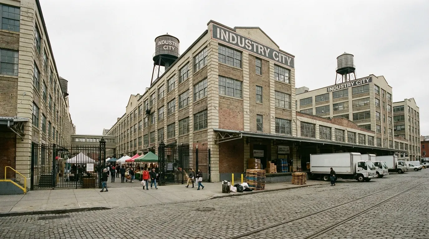
Confirms proximity to Industry City and the industrial backdrops, courtyard access points and likely security/loading activity a buyer should expect for session planning.
The visible courtyard entrance and signage are the same elements couples typically walk through on their way to or from indoor event spaces.
What couples typically see immediately after a session
For many Sunset Park sessions, especially those centered on the hilltop, it’s common to review a small batch of unedited selects on-site. This helps couples see how the skyline, trees, and park structures actually appear in frame under that day’s light and weather, rather than relying on idealized examples.
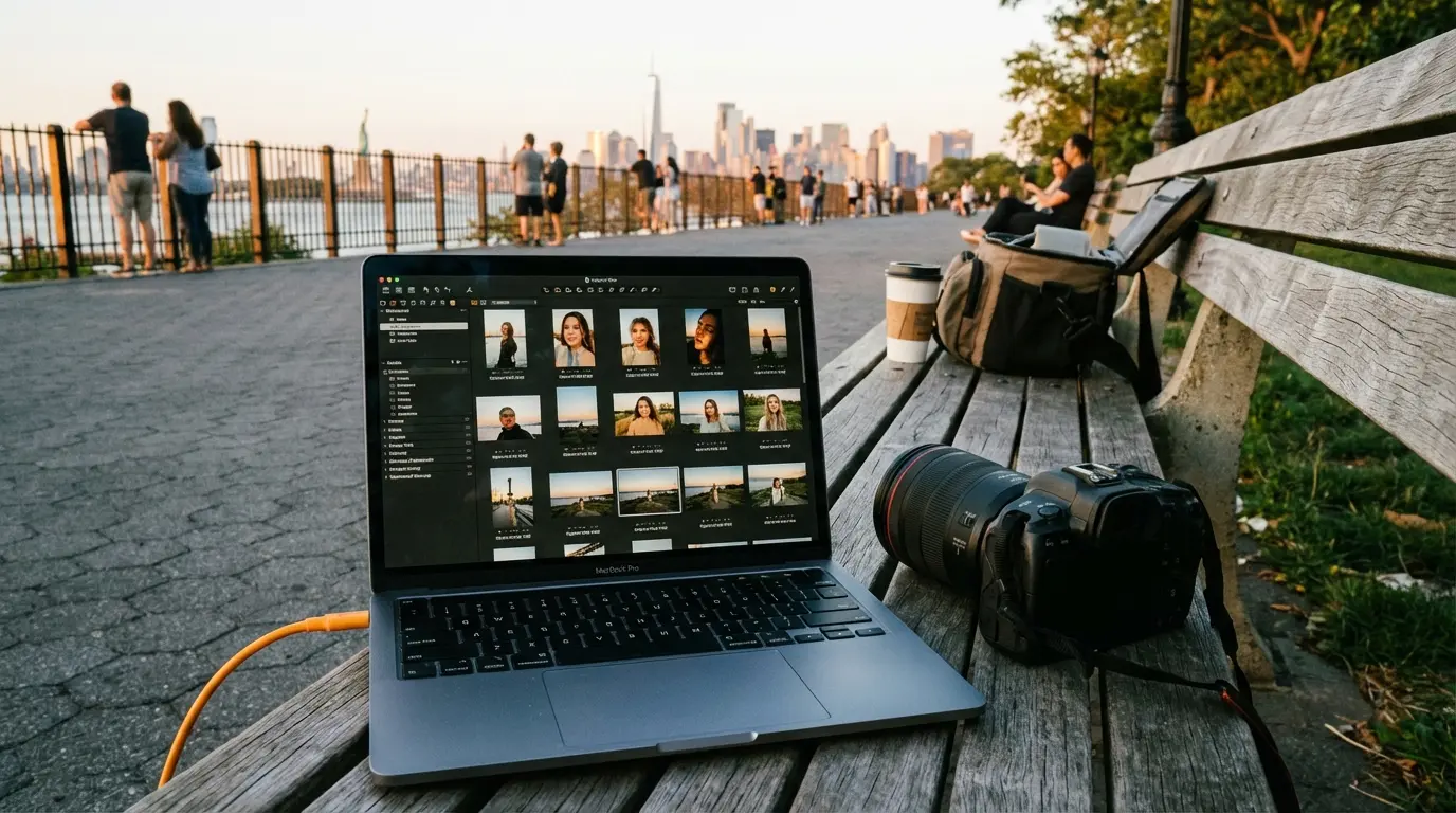
Shows realistic immediate deliverables: on-site unedited selects that reflect the hilltop compositions and light conditions a buyer can expect after a session.
The laptop view, bench, and overlook rail in the background mirror what couples see when they quickly confirm that the skyline, tree canopy, and crowd levels look the way they expected.
Everyday frictions to factor into a Sunset Park plan
Sunset Park’s daily patterns introduce a few consistent “frictions” that are useful to acknowledge upfront:
- Shade-tree canopy is uneven. Around the park perimeter, large trees create deep shade pockets that shift quickly as the sun moves, while parts of 5th Avenue have only small trees or none at all. This can produce mixed light across a group, especially if some people step just outside the shade.
- Stroller routes define peak congestion. Morning and early afternoon see steady stroller flows down toward the playground from the higher-numbered streets and back up again toward 5th and 8th Avenue shops. Crosswalks near schools and major corners stay especially busy at dismissal times.
- Corner stores create micro-crowds. Bodegas and groceries on corners are informal gathering points. People stop to talk, lean on railings, or cluster near the entrance, which can unexpectedly fill what looked like an open background a few minutes earlier.
- Street repairs are intermittent and visible. Utility work and asphalt patches appear frequently on the sloped side streets, sometimes with plates that make noise under passing cars. For photos, this affects where tripods or light stands can be safely placed and may introduce visual elements (cones, spray markings) into the lower part of the frame.
Planning with these patterns in mind tends to be more reliable than assuming empty sidewalks or pristine pavement.
Neighboring Areas in Brooklyn
Questions couples often ask about Sunset Park sessions
When is the best time of day for the hilltop overlook?
Late afternoon into golden hour works well because the west-facing slope catches low sun without tall buildings blocking it. Earlier in the day, the light is flatter and can be harsher, and on clear mornings the lower parts of the park sit in the hill’s shadow until mid-morning.
How does lighting on the hill compare to the commercial corridors?
The hilltop has open sky and more predictable, gradual shifts in light. On 5th and 8th Avenues, awnings, glass, and tree gaps create sharp bands of bright sun and deep shade, which can change within a few steps. That’s why many couples use corridors more for candid walking shots and keep formal portraits closer to the park or quieter side streets.
How crowded does the park get on weekends?
Expect a steady stream of families around the playground and overlook, especially on mild afternoons. The crowds move in loops, so there are brief gaps where a small group can step into position, but it’s rare to have the overlook completely to yourselves for more than a minute or two.
What should we know about Industry City access for photos?
Public sidewalks along the perimeter are straightforward to use, but interior courtyards and passages are managed spaces. Visible professional gear is more likely to be questioned, and some areas may be off-limits without prior permission, especially for longer or more complex setups.
Are the sloped streets difficult in formal shoes or gowns?
The main east–west streets closer to the park have noticeable incline, which can feel steep in heels or with long trains. Planning routes that minimize unnecessary up-and-down, and allowing a few extra minutes between locations, keeps people from rushing on slopes or uneven patches.
Where do couples usually get dropped off or park near the park?
Many use the blocks just east of the park between 5th and 7th Avenue for drop-off because they offer more curb space and slightly calmer traffic than the avenues themselves. For drivers, it’s common to circle for on-street parking on nearby residential blocks and then walk in.
Does weather or wind behave differently near the waterfront edge?
Yes. The industrial strip toward the harbor tends to pick up wind earlier than the central and eastern parts of the neighborhood. Veils, loose hair, and light fabrics move more there, which can be either a feature or a challenge depending on the look you want.
How much buffer time should we plan between the park and Industry City?
Even though the distance is short on a map, factor in 15–20 minutes to gather belongings, walk the slopes, and account for any pauses at busy crosswalks or around corner-store clusters. This keeps the schedule realistic without expecting empty streets.
How does stroller and school traffic affect movement and photos?
Around 5th and 8th Avenues, stroller routes and school dismissal times create waves of foot traffic that briefly fill sidewalks and crosswalks. This doesn’t prevent photos, but it does mean timing portraits slightly away from those peaks or positioning on quieter side streets to avoid constant interruptions in the background.